[:fr]
J’ai énormément de souvenirs de Macolin, y ayant passé passablement de temps dans ma jeunesse dans le cadre de camps d’entraînement. J’ai également gardé quelques souvenirs de la Hohmatt, ferme transformée, comme c’est souvent le cas dans la région, en restaurant. Une seule fois, j’avais traversé par les hauts mais j’étais alors descendu les gorges de Douanne pour prendre le bateau et revenir à Bienne.
Les années ayant passée, je me suis dit que cela serait amusant de refaire, ne serait-ce qu’un bout, de la randonnée effectuée alors. Ici, j’avais décidé de descendre à pied à la Neuveville. Ce faisant, j’avais la possibilité, si la météo devait devenir exécrable, de prendre le funiculaire de Prêles.
Rejoindre Macolin est très simple : il suffit d’emprunter le funiculaire qui part depuis Bienne. Pour rejoindre la station de départ, on a le choix de s’y rendre à pied ou de prendre le bus. L’un dans l’autre, si on tient compte du temps que l’on passe à attendre le bus, le temps nécessaire pour rejoindre la station de départ est peu ou prou le même. Tout dépend si on a envie de marcher ou pas. Ici, au vu de la randonnée qui m’attendait, j’avais opté pour le bus.
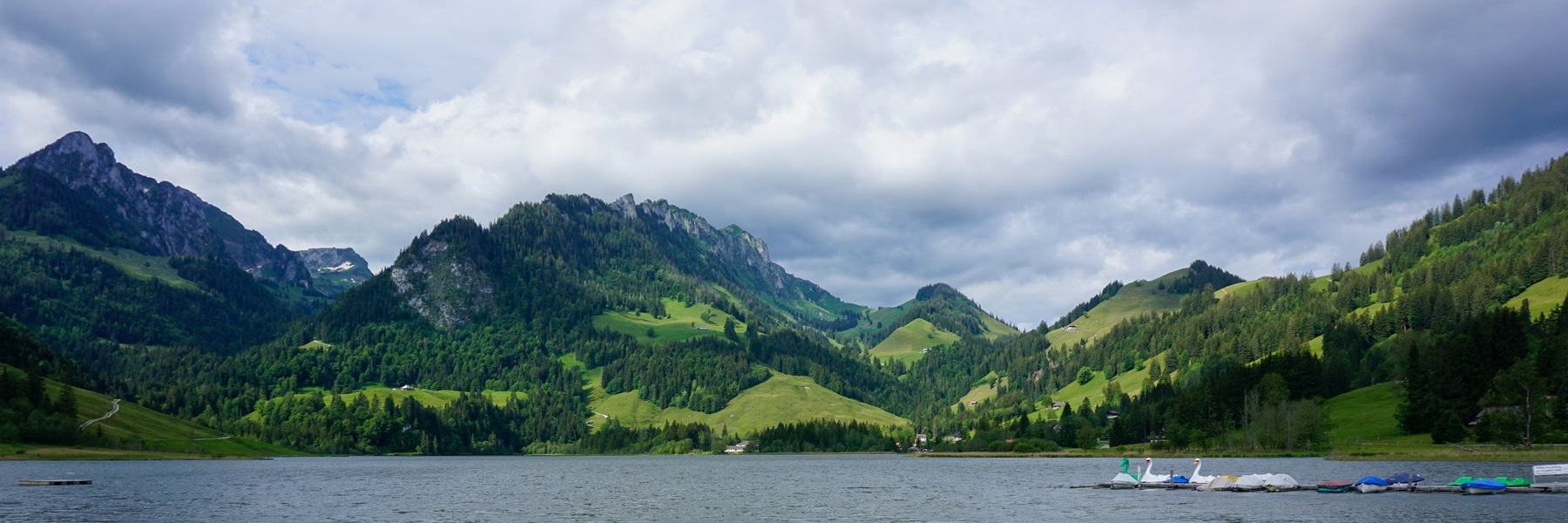
A l’arrivée du funiculaire, on commence par passer derrière les bâtiments administratifs du Centre National de Sport pour emprunter un chemin pédestre goudronné. Ce chemin rejoint l’ancienne salle de sport. Depuis celle-ci, on peut suivre la route décrivant un lacet pour rejoindre la Hohmatt (c’est celle-ci que nous suivions lorsque nous nous rendions à ce restaurant de nuit). Mais il est préférable de suivre le sentier balisé traversant la forêt et rejoignant la route un peu plus haut. Après la Hohmatt, il s’agit de monter encore un peu pour atteindre la Waldhaus, appartenant également au Centre National de Sport. Cet endroit est le point culminant de toute la randonnée.
Après avoir traversé une succession de forêts et de pâturages, on arrive en vue de Lamboing et c’est à cet endroit que l’on plonge en direction du vallon du Twannbach. La descente s’effectue le long d’un magnifique chemin pavé. Arrivé au fond du vallon, près d’anciens moulins, il faut alors traverser le ruisseau et remonter les pentes en face afin de rejoindre la forêt près de Prêles.
Dans le village de Prêles, on a la possibilité d’emprunter le funiculaire descendant à Légeresse. Cela peut être une variante intéressante si l’on devait être trop fatigué. Dans mon cas, j’avais poursuivi en montant en direction d’un petit col près du Pâturage du Haut. A partir de là, on ne fait que descendre en direction de la Neuveville. Ce faisant, on passe non loin de la fontaine de Velou, un grand bassin qui se rempli à partir d’une source. On passe derrière l’Envers de Châtillon (y avait-il un ancien oppidum à cet endroit ? Le nom le laisserait penser) et près du Gibet.
Après la longue descente, on ne tarde pas à arriver dans la bourgade de la Neuveville par l’ancien Faubourg et la Tour Rouge. Pour rejoindre la gare, on traverse alors la magnifique vieille ville pour ressortir par la Tour de Rive.
Itinéraire : Macolin – Hohmatt – Les Prés de Macolin – Les Moulins – Prêles – Fontaine du Velou – Gibet – La Neuveville
Distance : 15,5Km
Dénivellation : 370m positifs / 810m négatifs
Durée : 4h30
[:en]
I have a lot of memories of Macolin, having spent a fair amount of time there in my youth during training camps. I also kept some memories of the Hohmatt, a farm transformed, as is often the case in the region, into a restaurant. Only once, I had crossed by the heights but then I had gone down the Douanne gorges to take the boat and return to Bienne.
As the years passed, I said to myself that it would be fun to repeat, even just a part of the hike I did then. Here, I decided to go down to Neuveville on foot. In doing so, I had the possibility, if the weather became terrible, to take the Prêles funicular.
Reaching Macolin is very simple: just take the funicular which leaves from Bienne. To reach the departure station, you have the choice of going there on foot or taking the bus. All in all, if one considers the time spent waiting for the bus, the time needed to reach the departure station is the same. It all depends on whether you want to walk or not. Here, given the hike that awaited me, I opted for the bus.
At the upper funicular station, you start by passing by behind the administrative buildings of the National Sports Center to take footpath. This path joins the old sports hall. From there, you can follow the road in a bend to reach the Hohmatt (this is the one we followed when we went to this restaurant at night). But it is preferable to follow the marked path crossing the forest and joining the road a little higher up. After the Hohmatt, it is a matter of climbing a little further to reach the Waldhaus, also belonging to the National Sports Center. This place is the highest point of the entire hike.
After crossing a succession of forests and pastures, we arrive in sight of Lamboing and it is from this place that we go down towards the Twannbach valley. The descent takes place along a magnificent, paved path. Arriving at the bottom of the valley, near old mills, you must then cross the stream and go up the slopes opposite to reach the forest near Prêles.
In the village of Prêles, you can take the funicular going down to Légeresse. This can be an interesting variation if you are too tired. In my case, I continued climbing towards a small pass near the Pâturage du Haut. From there, we just go down towards Neuveville. In doing so, we pass not far from the Fontaine du Velou, a large pool which is filled from a spring. We pass behind the Envers de Châtillon (was there an ancient oppidum at this place? The name suggests so) and near the Gibet.
After the long descent, it does not take long to arrive in the town of Neuveville via the old Faubourg and the Red Tower. To reach the station, you then cross the magnificent old town to exit via the Tour de Rive.
Itinerary: Macolin – Hohmatt – Les Prés de Macolin – Les Moulins – Prêles – Fontaine du Velou – Gibet – La Neuveville
Distance: 15.5km
Altitude gain: 370m positive / 810m negative
Duration: 4h30
[:de]
Ich habe viele Erinnerungen an Magglingen, da ich dort in meiner Jugend im Rahmen von Trainingslager viel Zeit verbracht habe. Ich habe auch einige Erinnerungen an die Hohmatt, einen Bauernhof, der, wie so oft in der Region, in ein Restaurant umgewandelt wurde. Nur einmal hatte ich die Höhen überquert, aber dann bin ich die Twannbachschlucht hinuntergegangen, um mit dem Schiff nach Biel zurückzukehren.
Im Laufe der Jahre sagte ich mir, dass es Spass machen würde, die Wanderung, die ich damals gemacht hatte, auch nur teilweise zu wiederholen. Hier beschloss ich, zu Fuss nach Neuenstadt hinunterzugehen. Dabei hatte ich die Möglichkeit, falls das Wetter wirklich schlecht wurde mit der Prägels-Standseilbahn hinunterzufahren.
Magglingen ist ganz einfach zu erreichen: Nehmen Sie einfach die Standseilbahn, die von Biel aus startet. Um die Talstation zu erreichen, haben Sie die Wahl, zu Fuss dorthin zu gehen oder den Bus zu nehmen. Alles in allem ist die Zeit, die man benötigt, um die Talstation zu erreichen, wenn man die Wartezeit auf den Bus berücksichtigt, in etwa gleich. Es hängt alles davon ab, ob Sie laufen möchten oder nicht. Hier hatte ich mich angesichts der Wanderung, die mich erwartete, für den Bus entschieden.
Bei der Bergstation gehen Sie zunächst hinter die Verwaltungsgebäude des Eidgenössischen Sportzentrums und folgen einen asphaltierten Fussweg. Dieser Weg mündet bei der alten Sporthalle. Von hier aus kann man der Strasse in einer Kurve folgen, um zur Hohmatt zu gelangen (dieser Strasse folgten wir, als wir abends in dieses Restaurant gingen). Es ist jedoch besser, dem markierten Weg zu folgen, der den Wald durchquert und etwas weiter oben auf die Strasse trifft. Nach der Hohmatt geht es noch ein Stück weiter hinauf zum Waldhaus, das ebenfalls zum Sportzentrum gehört. Dieser Ort ist der Höhepunkt der gesamten Wanderung.
Nachdem wir eine Reihe von Wäldern und Weiden durchquert haben, erreichen wir Lamboing und von hier aus steigen wir in Richtung Twannbachtal ab. Der Abstieg erfolgt über einen herrlichen gepflasterten Weg. Am Talgrund angekommen, in der Nähe alter Mühlen, müssen Sie den Bach überqueren und die gegenüberliegenden Hänge hinaufsteigen, um den Wald in der Nähe von Prägels zu erreichen.
Im Dorf Prägels können Sie mit der Standseilbahn nach Ligerz hinunterfahren. Dies kann eine interessante Variante sein, wenn Sie zu müde sind. In meinem Fall stieg ich weiter in Richtung eines kleinen Passes in der Nähe der Pâturage du Haut. Von dort aus geht man einfach hinunter in Richtung Neuenstadt. Dabei kommen man unweit des Velou-Brunnens vorbei, einem grossen Becken, das aus einer Quelle gefüllt wird. Man geht hinter dem Envers de Châtillon vorbei (gab es dort ein antikes Oppidum? Der Name lässt es vermuten) und in der Nähe des Galgens vorbei.
Nach dem langen Abstieg dauert es nicht lange, bis man über den alten Faubourg und der Tour Rouge in der Stadt Neuveville ankommt. Um zum Bahnhof zu gelangen, durchqueren Sie die prächtige Altstadt und erreichen den Bahnhof durch die Tour de Rive.
Route: Macolin – Hohmatt – Les Prés de Macolin – Les Moulins – Prêles – Fontaine du Velou – Gibet – La Neuveville
Distanz: 15,5 km
Höhenunterschied: 370 m positiv / 810 m negativ
Dauer: 4h30
[:]

Article précédent
Article suivant