Téléphone : +41 22 757 67 57 frontdesk@dev.destination-montagne.ch

[:fr]Le vignoble genevois et la Haute Chaîne du Jura[:en]The Geneva vineyards and the Haute Chaîne du Jura[:de]Der Genfer Weinberg und die Haute Chaîne du Jura[:]

[:fr]

Le canton de Genève, même s’il n’est pas montagneux à proprement parler, offre quand même de belles randonnées. En particulier à l’entre-saison, il est agréable de pouvoir se balader dans la campagne genevoise (en été, il fait souvent trop chaud). Les régions du canton les plus propices sont certainement celles de Jussy, de la Champagne et du Mandement. Pour cette fois, j’avais opté pour le Mandement comme destination de randonnée.

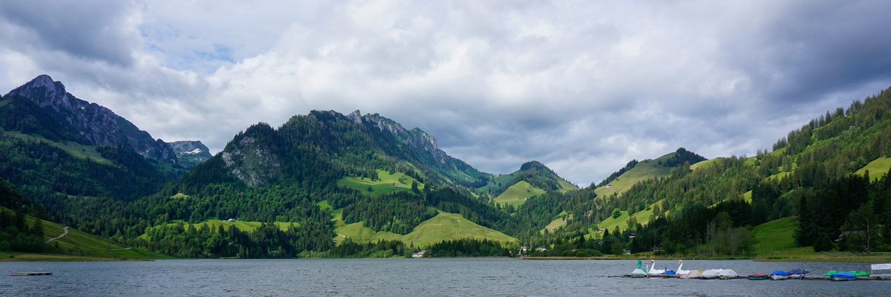
A travers le Mandement coule un ruisseau qui est fort apprécié par la population genevoise : l’Allandon. En effet, les beaux jours, les emplacements pour grillades sont pris d’assaut. Le revers de la médaille est que la forte affluence dans les années 70 et 80 a contribué à la dégradation d’un milieu naturel très fragile. C’est pourquoi, à la fin des années 80, il a été décidé de restreindre l’accès au vallon. C’est pourquoi seuls quelques grands parkings subsistent et que les accès en voiture jusqu’au bord du ruisseau ont été condamnés (c’était le cas encore dans les années 70). Le vallon de l’Allandon a ainsi gagné en calme, ce qui est un bien, car du point de vue du paysage, on a l’impression de se trouver dans la Drôme.

Au départ de La Plaine, il s’agit de traverser l’Allondon sur le pont du chemin de fer. Qu’on se rassure, on n’a pas à suivre les voies car un cheminement piéton avait été prévu dès le début. Celui-ci traverse les piliers du pont. Sur l’autre rive, j’ai suivi le sentier balisé qui monte et mène directement dans le village de Russin. En passant, il vaut la peine de contempler les quelques belles maisons de maître qui s’y trouvent. Au-delà du village, j’ai poursuivi le long du sentier balisé qui fait traverser le vignoble de Russin, passe près de la Chaumaz pour pénétrer dans les bois avant la descente sur les Granges.

Au bord de l’Allondon, j’avais suivi l’itinéraire balisé qui évite la route, sauf près du cimetière de Malval. On peut ainsi pratiquement suivre le ruisseau jusqu’au chemin de la Côte qui monte vers Dardagny. A cet endroit on a la possibilité de monter à Essertines ou de remonter le vallon du Roulave. C’est cette dernière option que j’avais choisie. Le vallon du Roulave est pittoresque. De plus, le ruisseau a érodé la roche de telle manière qu’apparaît le grès rouge qui ailleurs dans le canton est recouvert par une épaisse couche de molasse. C’est dans ce grès qu’ont été exploités quelques gisements d’asphalte. On voit encore quelques entrées de « mines ».

Au sortir du vallon du Roulave, j’ai continué à suivre l’itinéraire balisé passant par la Tuilière avant de traverser Dardagny et descendre le coteau de la Donzelle en direction de La Plaine.

Itinéraire : La Plaine – Pont sur l’Allandon – Russin – Monts de Russin – Les Granges (Malval) – bords de l’Allandon – vallon du Roulave – Tuilière – Dardagny – En Machy – A la Donzelle – La Plaine
Distance : 15,5Km
Dénivellation : 280m
Durée : 4h

[:en]

The canton of Geneva, even if it is not strictly speaking mountainous, offers beautiful hikes. Especially in the off-season, it is nice to be able to walk in the Geneva countryside (in summer, it is often too hot). The most favourable regions of the canton are certainly those of Jussy, Champagne and Mandement. For this time, I had opted for Le Mandement as a hiking destination.

Through the Mandement flows a stream that is greatly appreciated by the population of Geneva: The Allandon. Indeed, on sunny days, the places for grills are rushed at. The other side of the coin is that the strong afflux in the 70s and 80s contributed to the degradation of a very fragile natural environment. This is why, at the end of the 1980s, it was decided to restrict access to the valley. This is why only a few large car parks remain and the access by car to the edge of the stream has been condemned (this was still the case in the 1970s). The Allandon valley has thus gained in calm, which is a good thing, because from the point of view of the landscape, you have the impression of being in the Drôme.

From La Plaine, you must cross the Allondon on the railway bridge. Rest assured; you don’t have to follow the tracks because a pedestrian path had been planned from the start. This crosses the pillars of the bridge. On the other bank, I followed the marked path which goes up and leads directly to the village of Russin. By the way, it is worth contemplating the few beautiful mansions there. Beyond the village, I continued along the marked trail that crosses the Russin vineyard, passes near La Chaumaz to enter the woods before descending to the Granges.

On the bank of the Allondon, I had followed the marked route which avoids the road, except near the Malval cemetery. You can thus practically follow the stream to the Chemin de la Côte which climbs towards Dardagny. At this point you have the possibility of either going up to Essertines or going up the Roulave valley. I chose the latter option. The Roulave valley is picturesque. In addition, the stream has eroded the rock in such a way that the red sandstone appears, which elsewhere in the canton is covered by a thick layer of molasse. It is in this sandstone that some asphalt deposits have been mined. You can still see a few entrances to “mines”.

On leaving the Roulave valley, I continued to follow the marked route passing through La Tuilière before crossing Dardagny and descending the Donzelle hillside towards La Plaine.

Itinerary: La Plaine – Bridge over the Allandon – Russin – Monts de Russin – Les Granges (Malval) – banks of the Allandon – Roulave valley – Tuilière – Dardagny – En Machy – A la Donzelle – La Plaine
Distance: 15.5km
Aktitude gain: 280m
Duration: 4 hours

[:de]

Auch wenn der Kanton Genf streng genommen nicht gebirgig ist, bietet er dennoch schöne Wanderungen. Besonders in der Nebensaison ist es angenehm, in der Genfer Landschaft spazieren gehen zu können (im Sommer ist es oft zu heiss). Die günstigsten Regionen des Kantons sind sicherlich die Regionen Jussy, Champagne und Mandement. Für dieses Mal hatte ich mich für Le Mandement als Wanderziel entschieden.

Durch das Mandement fliesst ein Bach, der von der Genfer Bevölkerung sehr geschätzt wird: die Allandon. Tatsächlich werden an sonnigen Tagen die Grillplätze im Ansturm erobert. Die andere Seite der Medaille ist, dass der starke Andrang in den 70er und 80er Jahren zur Verschlechterung einer sehr fragilen natürlichen Umwelt beigetragen hat. Aus diesem Grund wurde Ende der 1980er Jahre beschlossen, den Zugang zum Tal zu beschränken. Aus diesem Grund gibt es nur noch wenige grosse Parkplätze und die Zufahrt mit dem Auto zum Bachufer ist verboten (dies war noch in den 1970er-Jahren der Fall). Das Allandon-Tal hat dadurch an Ruhe gewonnen, was gut ist, denn landschaftlich hat man den Eindruck, sich in der Drôme zu befinden.

Von La Plaine aus müssen Sie den Allondon auf der Eisenbahnbrücke überqueren. Seien Sie versichert, Sie müssen nicht den Gleisen folgen, da von Anfang an, ein Fussgängerweg eingebaut wurde. Dieser durchquert die Pfeiler der Brücke. Am anderen Ufer folgte ich dem markierten Weg, der hinaufführt und direkt zum Dorf Russin führt. Es lohnt sich, die wenigen schönen Villen dort zu betrachten. Hinter dem Dorf folgte ich dem markierten Weg weiter, der den Weinberg Russin durchquert, an La Chaumaz vorbeiführt und in den Wald gelangt, bevor er zu den Granges hinabsteigt.

Am Ufer der Allondon war ich der markierten Route gefolgt, die die Strasse meidet, ausser in der Nähe des Malval-Friedhofs. So können Sie praktisch dem Bach bis zum Chemin de la Côte folgen, der in Richtung Dardagny ansteigt. An diesem Punkt haben Sie die Möglichkeit, entweder nach Essertines oder ins Roulave-Tal hinaufzusteigen. Ich habe mich für die letztere Option entschieden. Das Roulave-Tal ist malerisch. Zudem hat der Bach das Gestein so erodiert, dass der Buntsandstein zum Vorschein kommt, der anderswo im Kanton von einer dicken Molasse Schicht bedeckt ist. In diesem Sandstein wurden einige Asphaltvorkommen abgebaut. Man kann noch einige Eingänge zu „Minen“ sehen.

Nachdem ich das Roulave-Tal verliess, folgte ich weiter der markierten Route, die durch La Tuilière führt, bevor ich Dardagny durchquerte und den Donzelle-Hügel hinab nach La Plaine ging.

Route: La Plaine – Brücke über der Allandon – Russin – Monts de Russin – Les Granges (Malval) – Ufer des Allandon – Roulave-Tal – Tuilière – Dardagny – En Machy – A la Donzelle – La Plaine
Distanz: 15,5 km
Höhenunterschied: 280m
Dauer: 4 Stunden

[:]

Laisser un commentaire

Votre adresse e-mail ne sera pas publiée. Les champs obligatoires sont indiqués avec *