

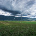
When with my parents we went to Engelberg, we often followed the road through Emmental and Entlebuch. In doing so, we had the opportunity, when the need arose, to be able to stop at one of the restaurants we found along the road. Thus, we often happened to stop at the Bahnhof restaurant in Trubschachen, which unfortunately disappeared in 2010. I remember that in the dining room there was a black and white poster representing the three famous Bernese peaks (Eiger, Mönch and Junfrau) in front of which was a very elongated mountain with a very steep face. I did not know the name of this mountain range then and it was only much later that I discovered that it was the Hohgant. Several times, I had approached it, without having been able to take a closer look. Being at the base of this mountain in 2017, in Eriz, I wondered if the steep face could be climbed easily. It was by consulting the topographic map that I realized that several trails existed.
There, we decided to go up the Chrinde, a funnel overlooking the Obere Breitwang pasture, to climb the western summit of Hohgant. In addition, we had anticipated that from the western summit (Westgipfel), the view would not be entirely clear and that we would have to climb the neighboring summit further east, rated at 2070m.
From Eriz, a good path climbs the ridge between the Chaltbach and the Fallbach and reaches the carriageway leading to the Untere and the Obere Breitwang. From this last chalet, the serious things begin. The slope becomes increasingly steep to climb the pasture before going to the left, almost flat. Some passages, without difficulty, however, require vigilance, and you should not be here in the event of a storm. After the crossing, the path continues to climb steeply and crosses some rocks where you must balance yourself with your hands. We advise you to observe the steep grassy slopes of the ledges: you can often see wild animals there.
Arrived in the basin, the path bends to the left to reach the wide ridge. There, we find the other officially marked path coming from the other funnel. Following the ridge, it does not take long to reach the outskirts of the Westgipfel. You can then follow a good track along the rest of the ridge. Arrived near the summit 2070m, it is worth crossing the slope to be able to climb to this summit from the east. The route is simpler.
We had made the right decision to climb to this summit, because we then enjoy a magnificent view of the mountains of Entlebuch: Beichle and Schrattenflue. From the west summit, one would not have such a clear view.
On the way back and before joining Grüeneberg, we had decided to climb the Trogenhorn. To reach the foot of it, following the ridge, a little surprise awaited us: you must go down a chimney, fortunately equipped with ladders. The chimney could be walkable without the ladders, but depending on the humidity, the descent could be very unpleasant.
At the foot of the Trogenhorn, we follow the eastern ridge. There is a short ladder to climb. Higher up, the ideal route is not always easy to find: the summit is made up of a pile of large blocks through which it is not always easy to cross. Fortunately, the rock forming them is very adherent Hohgant sandstone.
After the short descent from the Trogenhorn, we followed the path down along the Arnigrat. Flat passages alternate with steep slopes in which the best route is not always easy to find. Fortunately, this section is relatively short, and it does not take long to reach the Arni pasture where you find a good path.
From Grüenenberg, a little surprise awaited us: you must go up a few meters to reach the Hinter Sohl chalet.
Route: Eriz (Geissegg) – Obere Breitwang – Chrinde – Hohgant 2070m – Hohgant Westgipfel – Trogehorn – Arnigrat – Fallweidli – Eriz
Distance: 13.6km
Altitude gain: 1250m
Duration: 6h30
 Previous Post
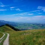 Next Post