

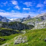
Beyond the interest of hiking, the Bernese side of the Gemmipass is worth of interest both historically and geologically.
It should first be mentioned that the main route (in the historical sense) descends from the Gemmi, follows the right bank of the Daubensee, crosses the Winteregg sideways before reaching Kandersteg. Nevertheless, and even though this other path has significant steep slopes, the path towards the Gasterntal has also been used since ancient times. It crosses the Gurnigel, which is on modern maps marked as the passage in the wall below the Tatelishore. However, in the Middle Ages, all pastures, including those of Spittelmatte, were referred to as Gurgnigel. The toponym of Spittelmatte (the hospice pasture) implies that there must have been there an establishment welcoming traveler crossing the Gemmi. If no trace of such a building has been found, it is because the place is located just below the Altels from which several landslides and serac falls occurred.
An interesting fact should also be highlighted: the cantonal border does not follow the mountain ridge of the Gemmipass but is located much further on the Bernese side. This explains the fact that the Schwarenbach inn is located entirely on Valais territory.
The Gasterntal, a magnificent Alpine valley, is worth descending via the Gurnigel from the Gemmi to reach it. Despite its wild appearance, this valley was the cause of a tragedy that occurred during the drilling of the first Lötschberg tunnel at the beginning of the 20th century. Indeed, it was then believed that as soon as they started digging the rock near Kandersteg, they would remain in the bedrock. This was without considering that the bottom of the Gasterntal is filled with 200m of water and rubble. Thus, when the workers crossed the rock to reach the Gasterntal, a landslide of rubble and water occurred, carrying the workers. Following this tragedy, cave-ins had formed in the bottom of the valley and several solutions were evaluated, one consisting of freezing the ground surrounding the tunnel so that it could be drilled safely. The solution ultimately adopted consisted of digging the tunnel along the Gasterntal to cross it much further upstream. This is why, by looking at the topographical maps, one realizes that the beginnings of the tunnels at the two entrances are perfectly aligned, but that the tunnel avoids towards the east.
Here we followed the left bank of the Daubensee which, even if it does not correspond to the historic route, is significantly less frequented. At the end of the Daubensee, we find the official path, and it doesn’t take long to pass the Schwarenbach inn. This inn is the subject of a short story by Guy de Maupassant which was published in a collection entitled “le Horla”. The precision of the descriptions suggests that de Maupassant had crossed the Gemmi and heard about what inspired his short story.
After passing Schwarenbach, it does not take long to reach a large plain, the Spittelmatte. It is near this that the cantonal border is located. A little further on, we follow the Schwarzbach to descend through Gurnigel towards the Gasterntal. This place is the only one where I have been able to see Alpine Columbines. There, it was too late in the season to be able to see any.
Once at the bottom of the Gasterntal, we follow the Kander to reach Kandersteg. Because of the heat that reigned those days, this torrent had transformed into roaring waters and the surroundings of these remind me of Calame’s painting “Thunder at the Handeck”.
Route: Gemmi Pass – left bank of the Daubensee – Schwarenbach – Spittelmatte – Gurnigel – Chluse – Eggeschwand
Distance: 14.5Km
Altitude gain: 160m positive/1305m negative
Duration: 4h30
 Previous Post
 Next Post