Arniloch, or also called Arni-Tobel is a popular destination for those looking for a bit of freshness in the middle of summer. Indeed, this gorge is sufficiently steep to prevent the sun’s rays from entering it. In addition, the presence of water adds a refreshing touch.
Some promotion had been made for the course of this gorge in the past century. Indeed, there are still antique postcards with the path of this gorge as a motif. In addition, at the exit of the gorge, a refreshment bar had been erected, a refreshment bar which had been reduced to ashes between the two wars and of which only the foundations remain.
The trail through the gorge had been closed for some time due to a thunderstorm which had damaged the trail. The current trail is no longer part of the official trail network of the canton of Nidwalden. As a result, signposts no longer mention this gorge and the markings have been covered in gray paint. However, the trail has been repaired and can be walked again as before. Moreover, it is interesting to note that the damage to the trail was minimal. Granted, there are a few more large boulders cluttering the trail just before changing banks and the footbridge had been washed away. But these are events that also happened on a regular basis in the past. Anyway, the trail seems well maintained and despite the erasure of the markings, one can easily find the trace on the ground. Only the section of the path at the bottom of the gorge to cross the Arnibach to reach Staldirain no longer seems to be maintained. Admittedly, this section is very short, and one can manage to ford the torrent, but there is no longer a footbridge. The crossing could be problematic if there were to be a lot of water.
To reach the start of the trail, one must cross the Aa below the Eugenisee to climb to Örtigen. Where the marked path descends in the direction of Äschboden, one must follow a path which does not take long to cross a gorge (the Egglitobel) to reach Eggli. Below this house the path begins, descending slightly towards a gate in the fence. The fence also marks the edge of the forest, and one follows a shady path to reach a small bridge over the Trüebenbach. Shortly after the bridge, one can still make out the path going to the right to go up to Staldirain.
The gorge path climbs on the right bank of the Arnibach always a little higher than the torrent. At one point, we find ourselves in front of a mouth. It is at this point that the path approaches the torrent and crosses an area cluttered with large blocks between which one must make one way. Shortly after, one crosses the torrent descending the Wangtobel on a footbridge. It is this footbridge that is torn from time to time during heavy rains. On the other bank, one climbs slightly through an often very humid area before starting the last steep ascent to the pastures.
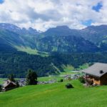
Once the pastures have been reached, we more or less follow the edge of the gorge to cross the fence as best we can (the passage that existed at the time has been removed) and reach the Arni-Wang chalet.
That day, I had followed the paved road leading to Untertrüebsee to cross the entire Gerschnialp and descend to Engelberg via the Chatzenbalmeli and the Bänklialp.
Itinerary: Engelberg – Eugenisee – Örtigen – Eggli – Arniloch – Wanghütte – Untertrüebsee – Café Ritz – Chatzenbalmeli – Bänklialp – Engelberg
Distance: 11.7 km
Altitude difference: 520m
Duration: 4 hours


 Previous Post
 Next Post