

The Bunderchrinde, even though the name is not very eloquent, is a pass connecting Adelboden and Kandersteg. It is located on route 1 of the Via Alpina. This route crosses the Alps from east to west, which in my opinion is a bad choice, even if it makes sense in view of the migratory movements of history. In fact, travelling the Via Alpina passes from east to west, you always have to climb to the passes with the sun on your back in the morning. It is far better to cross the passes in the opposite direction. You then have the advantage of being able to climb to the passes in a cool atmosphere. The Bunderchrinde is no exception.
The last and only time I crossed this pass was in, I almost dare not say, 1979. Travelling that route again not only allowed me to return to these places, but also to remember what I was at that time: a feeling of nostalgia and pride. For a long time, I had been planning to go down that road again, but living in Geneva, it would have been difficult to do it in one day. Now that I have changed my place of residence, it has become a little easier.
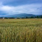
So, we took the bus from Frutigen to Adelboden and got off at the Oey stop. From there, soon after crossing the Allenbach and Entschlige, the serious things started. We had to follow the rather steep asphalt road to Bonderle. Strangely, I don’t remember this road. However, after descending along another road that crosses the Bunderlebächli, the memory of this valley, in which one finds quite a few ferns and butterbur leaves dancing in the morning air, was revived.
Continuing along the mark-signed route, we passed through a succession of pastures and forests, and it was only “I de Louwene” (at the avalanches) that we went beyond the last tree limit. From here, we move into the subalpine pastures and as we went up, the landscape became more and more mineral. Once you reach the “I de Schrickmatte” alpine pasture, you see two alpine routes (thus marked white-blue-white) that lead to the Lohner Hut. When you look at the upper one, it is hard to believe that it crosses the rocks. But it does.
Beyond that, we had to climb the steep slope leading to the Bunderchummi basin. It’s steep, but it’s because it must be an old frontal moraine, even though there are some valleys in the direction of the slope. In this basin, you have a short respite before beginning the crossing and the last steep 150m altitude gain to reach the pass. At the pass, the ridges on both sides present a curious stack of layers. There are rocks dated back to the Lower Cretaceous period.
On the other side, the terrain looks like the Adelboden slope: it is steep and stony. On the other hand, once you have crossed the scree and reached the pastures, things calm down a little to reach the Alpschele alpine pasture. From here, the trail crosses almost horizontally the slopes above a rock wall to reach an area of weakness on the wall, which is the only place where it can be crossed.
The descent on Ussere Ueschene is steep. At times, you really feel as if you are at the top of the first bends below. Luckily, thanks to the steepness, you quickly lose altitude and quickly reach the chalets. Below the huts of Ussere Ueschene, the map of marked trails indicates that you should follow the dirt road. However, it is more advantageous to cut the road by taking a vague, straight downhill trail.
Once on the road to Ueschene, it is worth following the mark-signed route, as it avoids having to walk along it (unless you want to stop at the Lohner Inn). Following the mark-signed route, you walk along a trail along the Alpbach, which joins the road twice. At the second one, if you want to get to the Kandersteg train station, it is better to follow the road for a few hundred meters to follow the marked path. This way, you do not have to follow the road from Eggeschwand to Kandersteg.
Further on you reach the bank of the Kander and follow the bank to Bütschels, where you must pass under the tracks to reach the station. Before Bütschels, you can see the steep slopes along the Kander. These are the result of the unloading of spoil from the first Lötschberg tunnel.
Route: Adelboden (Oey) – Bonderlen – I de Louwene – I de Schrickmatte – Bunderchummi – Bunderchrinde – Alpschele – Bärgli – Usser Üschene – Bütschels – Kandersteg
Distance: 15.5Km
Altitude gain: 1200m
Duration: 6h30
 Previous Post
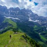 Next Post