Les Tablettes is a destination of choice in the Neuchâtel mountains. Indeed, these rocks form a promontory at the entrance to the Val de Travers. One then dominates the Gorges de l’Areuse and one find oneself facing the Creux du Van, the height of the large wall of which one can appreciate. There is also an unobstructed view of a good part of the Alps. Only the southernmost part of these is hidden by the long ridge of the Montagne de Boudry. Many access the Tablettes by leaving the car at La Tourne. Getting there is then the matter of a half-hour walks. However, the places are much less frequented than the “social network” destinations of the Gorges de l’Areuse and the Creux du Van. On the other hand, make no mistake about it, the whole ridge being wooded, it is not always possible to be able to appreciate a view completely devoid of branches hiding the vision.
I had been to Les Tablettes several times and I had wanted to go there by crossing. The idea came to me when I realized that both the start of this hike and the destination were easily accessible by train. Indeed, Chambrelien is on the La Chaux-de-Fonds line where the train must change direction to enter the uphill track (or downhill depending on the direction). The stop at Chambrelien is therefore assured for this reason. As for Les Ponts-de-Martel, a small train runs through the Vallée des Ponts and connects this village with La Chaux-de-Fonds.
From Chambrelien, one starts by climbing through the forest to reach Rochefort. This climb is pleasant because one progresses in the forest. It is only on the outskirts of Rochefort that one enters the meadows. After crossing the busy Val de Travers Road, one follows the Merdasson for a while before climbing, more and more steeply towards Les Tablettes. Just before arriving, the path joins a ridge which it climbs to the summit. This is where one has the best view of Lake Neuchâtel and the Val de Travers.
Further on, the path runs along the ridge in the direction of Solmont, offering here and there a few viewpoints over the valley and the Montagne de Boudry. If one wants to reach Les Ponts-de-Martel by following the marked trails, one must go down to the angle of rocks overlooking Noiraigue. In doing so, one must then go up the Combe Hory to regain the lost altitude. This is why I decided, after Solmont, to cut through the woods to reach a forest path leading down to Brot-Dessus.
After crossing this village, one reaches the wide plain of the Vallée des Ponts. The path passes between marshes and peat bogs, and one should not miss the two mineral water springs, a sulphureous and a ferruginous one. They are found where the path crosses the Grand Bied and one should not miss going to taste these waters. The presence of mineral water springs in a limestone massif remains a mystery to me, who believed that they only existed in the Alps.
Shortly after, one reaches the village of Ponts-de-Martel, where one can take the little train to La Chaux-de-Fonds. Be careful, however, to consult the timetable beforehand, the train does not run at certain times, requiring longer alternatives.
Itinerary: Chambrelien – Rochefort – Les Tablets – Solmont – Brot-Dessus – Les Ponts-de-Martel
Distance: 14.5km
Altitude gain: 800m
Duration: 5h


 Previous Post
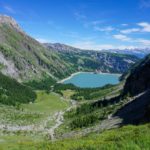 Next Post