On that day, the weather forecast was not too bad. At the same time, for practical reasons, we had favored the Boudry area. However, we had absolutely no desire to follow the Areuse Gorges trail for two reasons. First, the upper section on the Saut de Brot side was closed for work reasons. In addition, given the season, it was almost certain that the Gorges path would be in the shade all day long. On the train to Champ du Moulin, we were surprised by the number of passengers. Some, according to discussions, planned to go down the Gorges de l’Areuse, others to go up the Creux du Van.
From the Champ du Moulin, instead of descending towards the Areuse, the first section is to follow the asphalt road, fortunately not very frequented. At a bend, after walking 500m, you leave the road to take a path that runs above the railway track. This trail must be used by workers to inspect the safety nets. There are short ascents and descents, resulting in some elevation gain.
There are two aspects that we particularly enjoyed following this route. First, we’re mostly in the sun, even at this time of year. Even if you hear the Areuse running in the valley, you’re not envious of those who follow the Gorge Trail: they’re in the shadows from start to finish. Secondly, this trail, which is not advertised at all on social media, attracts fewer people. So, you’re hiking in a pretty lonely environment.
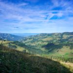
After crossing some rather deep and shaded mounds, one climbs quite steeply to reach a small structure overlooking the railway tracks, appropriately named “Le Belvédère”. From here, one has a view of the valley of the Areuse and part of the Creux du Van.
A little further on you pass Cottencher’s Cave, the entrance of which is not directly on the trail, but a little higher up on a rock bar. Traces on the ground clearly indicate the path. This cave is normally closed due to its prehistoric importance. Many artefacts dating back to the Middle Paleolithic period have been found here. The site is of national importance because some of the earliest evidence of Swiss occupation can be found here.
After reaching Chambrelien, you can descend towards Boudry, reaching the end of the Gorges de l’Areuse. But instead of descending directly, it is worth going to the viewpoint mentioned on the signposts. The view is less clear than at the Belvedere, but nevertheless very beautiful. Instead of retracing your steps to follow the marked trail, you can easily follow the edge of the rocks to pass near the rocky pit of the Grotte de Vert and reach the trail down into the gorges. Here, the atmosphere changes completely because at the bottom of the gorges you are in the shade, and it is very wet. Also, we suddenly see a lot more people.
Further on, one passes in front of the Chanet power plant, through the windows of which one can see the spiral cases inscribed “Picard et Pictet & Cie Genève 1913”. This mechanical engineering company was best known to produce luxury cars, the famous Pic-pic. The company went bankrupt shortly after the First World War and it was to limit financial losses that a new company was founded, the renowned Ateliers des Charmilles.
Route: Le Champ du Moulin – Cottencher Cave – Chambrelien – Pont de Vert – Boudry
Distance: 8Km
Altitude gain: 230m
Duration: 2h30


 Previous Post
 Next Post